")
")


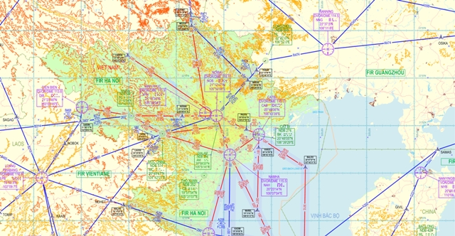
MAP/CHART
The Civil Aviation Authority of Viet Nam provides a range of aeronautical charts for use by all types of civil aviation. The Aeronautical Information Service produces the charts which are part of the AIP. Other aeronautical charts are produced by the Viet Nam General Department of Land Administration.
The following kinds of aeronautical map/chart and flight procedures shall be made available at the Map and Flight Procedure Division (VNAIC):
- Aeronautical chart scale 1:250.000
- Aeronautical chart scale 1:500.000
- Aeronautical chart scale 1:1.000.000
- Aerodrome Chart/Heliport Chart – ICAO
- Aircraft parking/Docking Chart – ICAO
- Aerodrome Ground Movement Chart – ICAO
- Aerodrome Obstacle Chart – ICAO Type A
- Aerodrome Obstacle Chart – ICAO Type B
- Precision Approach Terrain Chart – ICAO
- En-route Chart – ICAO
- Area Chart – ICAO
- Standard Departure Chart – Instrument (SID) – ICAO
- Standard Arrival Chart – Instrument (STAR) – ICAO
- Instrument Approach Chart – ICAO
- Visual Approach Chart – ICAO
- ATC Surveillance Minimum Altitude Chart – ICAO.
- Other kinds of map/chart for air navigation.
The above mentioned maps/charts are also published in the Viet Nam’s AIP.
To gain more detailed information on aeronautical map/chart, please contact:
MAP AND FLIGHT PROCEDURE DIVISION
|
AERONAUTICAL MAP/CHART The Civil Aviation Authority of Viet Nam provides a range of aeronautical charts for use by all types of civil aviation. The Aeronautical Information Service produces the charts which are part of the AIP. Other aeronautical charts are produced by the Viet Nam General Department of Land Administration. The following kinds of aeronautical map/chart and flight procedures shall be made available at the Map and Flight procedure Division (VNAIC):
· Aerodrome Chart ; · Aircraft Parking/Docking Chart; · Aerodrome Ground Movement Chart; · Aerodrome Obstacle Chart; · Area Chart; · Standard Departure Chart – Instrument (SID); · Standard Arrival Chart – Instrument (STAR); · ATC surveillance minimum altitude chart; · Visual Approach Chart; · Instrument Approach Chart; · En-route Chart; · Other kinds of map/chart for air navigation. The above mentioned maps/charts are also published in the Viet Nam’s AIP. To gain more detailed information on aeronautical map/chart; please contact: MAP AND FLIGHT PROCEDURE DIVISION 5/200 Nguyen Son Street, Bo De ward, Long Bien district, Ha Noi
Phone: +84-4-38729581 Fax: +84-4-38725687 AFTN: VVVVYOYM Email: This e-mail address is being protected from spambots. You need JavaScript enabled to view it |