GEN 2.3 CHART SYMBOLS
The aeronautical symbols used on chart contained in the AIP and other aeronautical charts series listed in GEN 3.2 correspond in every respect to in everythe internationally agreed symbols contained in ICAO Annex 4 - Aeronautical charts and the Aeronautical Charts Manual Doc 8697 - AN/889. Beside, a number of symbols, not yet internationally recognized, are also used.
1 Aerodromes
1.1 Charts other than approach charts
Civil (land) |  |
Military (land) |  |
Joint civil and military (land) |  |
1.2 Approach charts
The aerodrome on which the procedure is based |  |
Aerodrome affecting the traffic pattern on the aerodrome on which the procedure is based |  |
DME distance |  |
VOR radial | 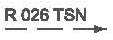 |
Radio market beacon |  |
Instrument landing system (ILS) - plan view | .jpg) |
Instrument landing system (ILS) - profile view | .jpg) |
1.3 Aerodrome installations and lightings
Aerodrome reference point (ARP) |  |
Taxiways and parking areas |  |
VOR check-point |  |
Runway visual range (RVR) observation site |  |
Hard surface runway |  |
Stopway |  |
Clearway | |
Control tower |  |
Barrette |  |
Point light |  |
Point light |  |
Obstacle light |  |
Aeronautical ground light |  |
Wind direction indicator (lighted) |  |
Wind direction indicator (unlighted) |  |
Landing direction indicator (lighted) |  |
Landing direction indicator (unlighted) |  |
Stop bar |  |
Runway-holding position |  |
2 Air traffic services
Flight information region (FIR) |  |
Aerodrome traffic zone |  |
Scale-break (on ATS route) |  |
ATS route designator |  |
Two way route | 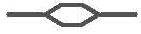 |
One way route |  |
A by-pass where an ATS route crosses the reporting point of another ATS route (not required to report) |  |
Compulsory |  |
On request |  |
Final approach fix (FAF) |  |
Altitude/flight level "window" | 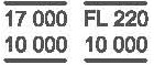 |
"At or above" altitude/flight level |  |
"At or below" altitude/flight level | 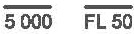 |
"Mandatory" altitude/flight level |  |
"Recommended" altitude/flight level |  |
"Expected" altitude/flight level |  |
3 Airspace restrictions
Restricted airspace (prohibited, restricted and danger) | 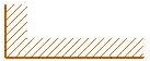 |
Common boundary of two areas |  |
4 Obstacles
Obstacles |  |
Lighted obstacles |  |
Group obstacles |  |
Lighted group obstacles |  |
Elevation of top |  |
5 Radio navigation aids
Basic radio navigation aid symbol |  |
Non-directional radio beacon (NDB) |  |
Distance measuring equipment (DME) |  |
Compass rose |  |
VHF omni-directional radio range (VOR) |  |
Collocated VOR and DME radio navigation aids (VOR/DME) |  |
6 Additional symbols for use on paper and electronic charts
Minimum sector altitude (MSA) | 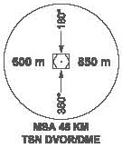 |
Holding | 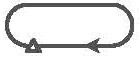 |
Missed approach track | 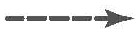 |
Runway |  |
7 Symbols for use on on aerodrome obstacle charts - Type A, B and C
Building or large structure |  |
Transmission line or overhead cable | |
Railroad |  |
8 Railroads
Railroad (single track) |  |
Railroad (two or more tracks) | 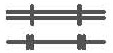 |
Railroad (under construction) |  |
Railroad bridge | 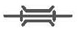 |
Railroad tunnel |  |
Railroad station |  |
9 Highways and roads
Dual highway |  |
Primary road |  |
Secondary road |  |
Trail |  |
Road bridge | 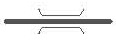 |
10 Hydrography
Shore line (reliable) |  |
Large river (perennial) |  |
Small river (perennial) |  |
Canal |  |
11 Topography
Spot elevation |  |
National bench mark |  |
12 Miscellaneous
Boundaries (international) |  |
Outer boundaries |  |